


Természetjáró, a túratervező
Опис програми Természetjáró, a túratervező
Онлайн-туристичний путівник по Угорщині, спеціально розроблений для туристів, велосипедистів, трейларанів, скелелазів і любителів водних видів спорту, містить вбудований планувальник турів, а також сотні рекомендованих турів і тисячі пам’яток, усі з докладним описом і великою кількістю фотографій. , яку зручно переглядати на інтерактивній карті. Доступно безкоштовно, з можливістю підписки для розширення функціональності.
Функції
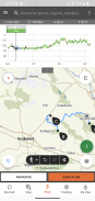
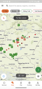
• Різноманітні інтерактивні, масштабовані, векторизовані світові туристичні карти з усіма позначеними маршрутами, що показують ваше поточне місцезнаходження
• Зручний спосіб спланувати свій власний тур на карті та одразу отримати профіль тривалості, тривалості та висоти
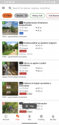
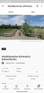
• Більше тисячі рекомендованих турів для пішоходів, байкерів, бігунів і веслувальників на каное з практичними даними, детальним описом найкращих пам'яток поблизу, природним і культурним фоном, якісними фотографіями та інформацією про те, як туди дістатися
• Тисячі рекомендованих пам'яток в Угорщині, включаючи оглядові вежі, природні панорамні точки, лісові поїзди, фортеці та музеї, з детальним описом, якісними фотографіями та інформацією про те, як туди дістатися
• Сотні помешкань, включаючи хатинки, туристичні готелі та апартаменти, поблизу маркованих стежок
• Корисні колекції з картою: пляжі навколо озера Балатон, арени для катання на ковзанах, ботенічні сади, найкращі маршрути для бігу, місця для скелелазіння, тури для людей з обмеженими можливостями тощо.
• Примітки, попередження та закриття
• Завантажте розділи карти, екскурсії та пам'ятки для використання в автономному режимі
• Оперативна навігація по маршруту з поточним профілем висоти та голосовими інструкціями
• Запишіть свій маршрут
• BuddyBeacon: поділіться своєю позицією з друзями в прямому ефірі
• Повний Угорський блакитний тур з офіційними частинами та маршрутом, POI та місцями проживання
• Синхронізувати весь вміст між комп’ютером і мобільними пристроями, на яких запущено програму
• Перевірте місцевий прогноз погоди
• 3D-політ: віртуальний огляд екскурсії з висоти пташиного польоту
• Вбудовані корисні інструменти, такі як пікшукач(Skyline) і компас із вашим поточним положенням
• Служби спільноти: оцінюйте та діліться вмістом із друзями
Розумні годинники з ОС WEAR від Google
Поглянувши на свій розумний годинник, ви отримаєте інформацію про своє положення GPS на карті. Ви можете записувати шляхи, отримувати дані відстеження та здійснювати навігацію за маршрутами. Використовуйте плитку програми, щоб легко отримати доступ до найближчих маршрутів.
Виключно для членів Pro
Будь куди завгодно: Outdooractive Pro працює в автономному режимі без мобільного зв’язку та сигналів даних. Також можна створювати необмежену кількість списків, а додаток не містить реклами. Крім того, ви можете переглядати супутникові зображення, унікальну карту Outdooractive із понад 30 мережами туристичних стежок та офіційні топографічні карти від таких постачальників:
Великобританія Ordnance Survey, Landranger, Explorer
Інформація про землю Нової Зеландії
Юта USGS
Німеччина BKG
Австрія BEV
Швейцарія swisstopo
Франція IGN
Іспанія CNIG
Італія
Нідерланди PDOK
Картверкет Норвегії
Данія Кортфорсінінген
Швеція Lantmäteriet
Національна служба землеустрою Фінляндії
GSI Японії
Глобальна карта
Виключно для учасників Pro+
Pro+ також містить офіційні карти від альпійських асоціацій, а також преміальні карти від KOMPASS.
Якщо у вас є запитання чи пропозиції, відвідайте
https://www.termeszetjaro.hu/hu/p/gyakran-ismetelt-kerdesek/41050512 /
Наша версія для комп’ютера:
https://www.termeszetjaro.hu/
Слідкуйте за нами на Facebook:
https://www.facebook.com/Termeszetjaro.hu/
Зв'яжіться з нами:
termeszetjaro@termeszetjaro.hu
Докладніше про картку TEKA:
http://www.termeszetjarokartya.hu/
Természetjáró, a túratervező - інформація про APK
Версія APK: 3.19.4ID пакета: com.outdooractive.mtszОстання версія Természetjáró, a túratervező
Інші версії


Додатки в цій категорії

Вам також може сподобатися...


